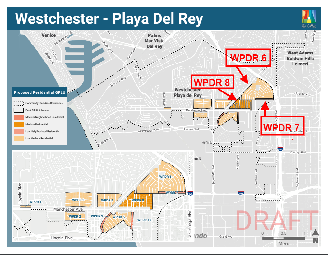


Housing & Then More Housing
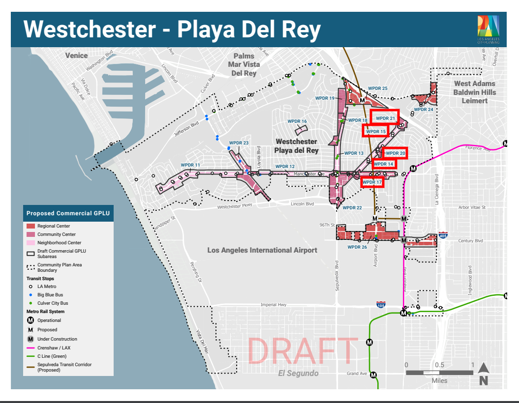
A few weeks after the Residential Map was discovered, we found the Commercial Draft 2.0 Map, which proposes additional upzoning of residential homes to high density commercial mixed use, affecting hundreds of homes on residential streets lining every corridor of our community: Sepulveda, La Tijera, Manchester and Lincoln.
This Commercial Map proposes upzoning over 650 homes directly, and impacts another 600 adjacent homes. A total of over 1200 homes are impacted on residential streets lining our community’s biggest corridors under the Commercial Map plan.
We Are The Wrong Community For More Housing
City Planning seems to have forgotten (or is ignoring) the fact that Westchester/Playa is uniquely impacted by LAX and that all of our corridors are used by Angeleneos and world travelers to access the airport.
As residents, we live every day with the unmitigated impacts of traffic, poor air quality and noise from LAX. Upzoning our corridors for additional commercial mixed use (with a whole lot of new residential units) will lead to yet more negative environmental and traffic consequences for our community.
Westchester corridors now are designed to distribute traffic to LAX from the 405 and support local resident uses. They are lined with low-rise residential facing inward and away from the corridors in many areas of our community.
LAX-Focused Corridors Require Rear-Facing Ingress & Egress
City Planning’s overarching goals for corridors in general is to promote new housing in mixed-use projects along major corridors supported by existing transportation infrastructure, and in pedestrian-oriented areas.
In Westchester/Playa, egress and ingress will have to be on the residential side of buildings, as DOT will never approve curb cuts on the corridor side for traffic reasons. Additionally, Westchester has at least one Community Design Overlay (CDO) in effect that legally requires rear-facing ingress and egress.
This will force commercial ground floor egress, ingress and signage to be facing our neighborhoods on our residential streets, leading to additional cut-through traffic in all of our Westchester/Playa del Rey neighborhoods, especially if the corridors are impassable with added residential density.
Also important to note, when converting our residential streets to commercial mixed use, City Planning is not going to provide a blueprint for an actual planned use or community such as Playa Vista. They are simply rezoning, so that homeowners can sell to developers in a parcel by parcel approach to development.
This approach does not produce a substantial amount of new housing, and there are no requirements for adding affordable housing in this plan.
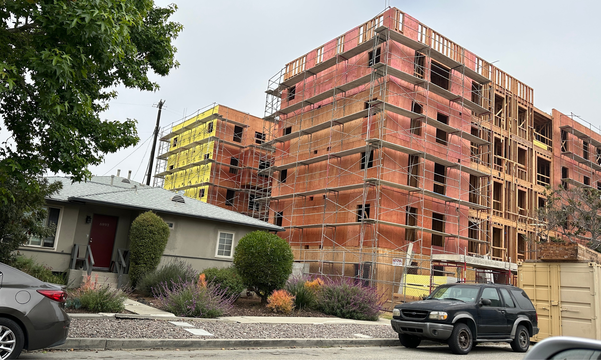
Homeowners quite likely will face a devaluation of their property if the Commercial Map is adopted as presented. And the end result will be that our corridors will have a hodgepodge aesthetic effect – think of portions of La Brea, where you see a house next to a gas station next to a small building – can we say ugly?
This is not thoughtful development that will benefit our community. It is simply a green light for developers to build practically anything anywhere they can grab a cheap lot, with no parking and little affordable housing.
Which Streets Are Being Upzoned to Commercial Mixed Use?
In the current iteration of the Commercial Map, residential streets lining the corridors of Manchester, Sepulveda, La Tijera and Lincoln would be converted to Commercial Mixed Use, replacing single family homes and other low-rise duplex/ triplex units on the following streets:
Alverstone Ave (West of Sepulveda)
Naylor Ave (East of Sepulveda)
Arizona Ave (West of Sepulveda)
85th Place (North of Manchester)
86th Place (South of Manchester)
86th Place (North of Manchester)
Kittyhawk Ave (East of La Tijera)
Flight Ave (West of La Tijera)
Manchester Ave (North and South)

Where Is The Fair Housing The City Wants To Promote?
It has not gone unnoticed by our community that the bulk of the proposed density in all three proposed maps is on the east side of our community, in Osage and on corridors near Osage. This is also an area already heavily impacted by poor air quality and LAX-related traffic.
This brings up questions about the equitable distribution of upzoning in our community. The City’s current plan targets the most socioeconomically diverse parts of our community, the very people the City is supposed to be helping under current and proposed housing policy. The plan targets entry level housing and homeownership and threatens to displace our vulnerable RSO (rent control) and Section 8 community members, all to build market rate boxes.
And did I mention the planned 15-story buildings? The current Commercial Map allows for the potential for high density commercial mixed use of up to 15 stories with no gentle transition on streets currently lined with single family homes.
Further, the plan provides for no added green space, which Westchester/Playa is already sorely lacking. And most importantly, the plan fails to recognize that LAX modernization and growth will continue to impact our corridors which are a gateway to a world airport, LAX.
The Community Alliance Has A Better Plan
Fortunately, we have a better plan. After countless hours of meetings, rallies, petition gathering and other events, The Community Alliance understands what our community wants and is doing our darnedest to make the planners listen. Will they heed the will of our community? That is the $64,000 question.
Please sign and share our petition!
** The views expressed in this post are Cory’s alone, and should not be construed in any way as an opinion of any other group.**
 About Cory Birkett Cory Birkett is a 25-year Westchester/Playa resident and alumna of LMU. Her background in education led to her active parent involvement in many local schools since her daughter was in preschool. She has held leadership roles in the PTAs and Governing Boards of schools such as WPNS, Open Magnet Charter, WISH Middle and El Segundo High School. Her commitment to helping schools implement social-emotional programs and community service initiatives has made her a driving force behind positive changes in the local education system. As an appointed community member of the Westchester/Playa Neighborhood Council’s Planning and Land Use Committee and Ad Hoc Community Plan Update Committee, she advocates for strategic and thoughtful development that enhances affordable housing opportunities while maintaining Westchester/Playa’s unique neighborhood character.
Cory’s career path led her through the world of print and online publications as an editor. For the past 15 years, she has been a local realtor helping home buyers and sellers navigate the unique Silicon Beach neighborhoods of Westchester, Playa del Rey and beyond. Cory offers personal guidance, ensuring her clients are informed about all aspects of a home sale or purchase, including expert knowledge of local schools and neighborhoods. Cory is dedicated to serving the people and communities she loves and spends much of her free time volunteering for local organizations.