Do We Finally Have The Full Plan?

The CPU Process Starts

Draft 1 of our Community Plan Update from City Planning was a very straightforward affair with lots of community meetings and community input back in 2020. Then COVID happened and everything stopped. Post-COVID, the city seems to have forgotten it has community stakeholders, at least in Westchester Playa.

The CPU Process Restarts But Differently

As the city started back up with our CPU, it formed a 52-member Advisory Group with only five members from Westchester even though we are 25% of the four westside communities working our CPUs together. Oh, and four of those people were chosen to represent special interest groups, not us. More about the Advisory Group here.

The Advisory Group would be the only party in the conversation with Planning about our CPU, if Planning had its way. They were only meeting with the Advisory Group and were only posting updates to that group’s website.

Then the public caught wind of what was going on and groups like members of our Alliance started shining a light on the new drafts and demanding meetings with the planners.

The Advisory Group strategy was a 180 degree pivot from the full public strategy of the first draft and an abject failure.

Where We’re At Now In The Process

Below are the maps provided to the Advisory Group but not stakeholders (unless you happened to know where to look and happened to do so, like we did).

These maps are supposed to be consolidated before the end of the year and we’re told the public gets more input, but we fear that input will be in the EIR process when the maps are mostly set.

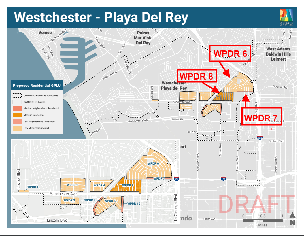
The first map was called the Residential Map. We thought it was the full residential plan and we all almost had heart attacks by the gross density proposed in that map, especially around the Sepulveda/Manchester Quadrant.

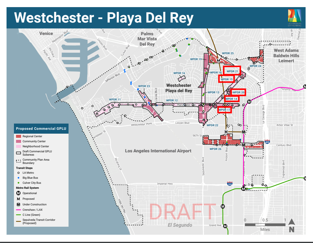
Then the Commercial Map dropped and we were shocked to see how much more density the city thinks we are willing to pile on top of commercial businesses, in addition to what is in the Residential Map.

Oh, and then the Industrial Map dropped. What? It took me several reads to discover that yet more housing is contained on this map.

Seriously? Did you know that Westchester is forecast to decline in population? Why do we need three maps worth of grossly densified high-rises in a community that was built for single family homes and doesn’t have the infrastructure to be the Wilshire Corridor of the beach cities?

Not to mention a community landlocked by the 405, Marina Channel/Kentwood Bluffs, Pacific Ocean and LAX.

And speaking of LAX, these densification plans are going to wreak havoc with LAX’s plans to grow flights. The whole plan is stupid. It’s not innovative and it’s not inspired. It’s straight up gross densification for the sake of stuffing in a bunch market rate boxes.

Is This The Whole Plan?

We’ve been told our planners are done dropping maps, other than a consolidated map promised for September. Hopefully we’re looking at the whole draft plan now.

As a reminder, we are in the CPU process with three other westside communities – Venice, Palms/Mar Vista/Del Rey and West LA under the cutesy name of “Planning The Westside.”

Why the other CD-11 communities of Brentwood, Pacific Palisades and Ladera aren’t in this “westside” plan with us remains a mystery, although we have some theories.

The combined maps can be found here, here and here. But don’t forget you have to also read the separate supporting documents to even begin to read the maps (correspondence tables, GPLU keys, policy documents, housing element and maybe things we don’t even know about yet).

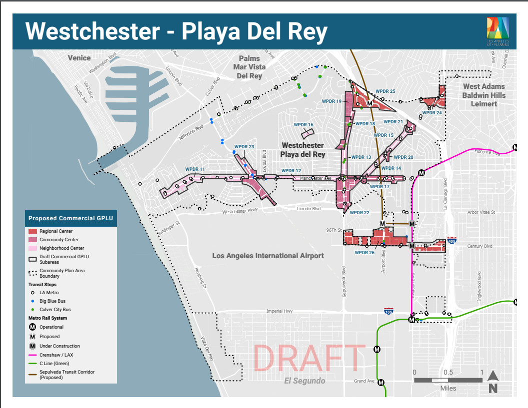
For your convenience, I’ve excerpted images of the Westchester Playa maps below for a quick visual, but as mentioned above the maps do not tell the entire story, sadly.

The Westchester Playa Plan

The entire plan is so grossly full of density and high-rises, even the city couldn’t capture it all in one map. Here are our three maps, all with residential implications.

The Residential Map

The residential map was apparently drawn with a new Manchester/Sepulveda TOC in mind, as well as the new Hindry light rail metro station. More has been written on the TOC here and the Osage commercial plan here.

click to enlarge

The Commercial Map

click to enlarge

The Industrial Map

click to enlarge

Does This Plan Provide Affordable Housing?

A lot of people accept the “we need density” narrative because they are told that is how we get affordable housing.

The narrative is, sadly, partially true. The only mechanism the city currently uses to incentivize affordable units is to provide extras to market rate developers to build a couple of token affordable units.ย 

In fact, I’ve been in meetings with the planners recently where they admit we need gross densification to meet our affordable housing targets.

Did you take that in? We’re supposed to absorb thousands of ugly boxes we don’t need to get a few affordable units. Does that make any sense? Is that a good use of our resources?

How about the city ponies up to subsidize developers to build more affordable units instead of giving away our low density communities for random acts of blighted densification??

Are You Mad Yet?

What do you think about the maps and the plan? Not mad yet? Read this.

Mad enough to sign our petition? Find it here.

Mad enough to hit the streets with us? Find out how you can help here.


Tracy is active in a number of local community organizations including the Neighborhood Council PLUC, Neighborhood Council Ad Hoc CPU Committee, Kentwood Home Guardians and Emerson Ave Community Garden Club. The views expressed in this post are Tracyโ€™s alone, and should not be construed in any way as an opinion of any other group. Are you planning a meeting with the planners? Have Tracy along to make sure you get the same information other community members get. Are you willing to host a group of your neighbors for a talk? Tracy would be happy to join you.


About Tracy Thrower Conyers Tracy Thrower Conyers is a long-time resident of Westchester 90045. Tracy closely follows local politics, political players and social chatter relevant to Westchester. Youโ€™ll frequently find her at Neighborhood Council meetings, as well as on all the social platforms where 90045 peeps hang out. Tracy is a real estate broker and founding principal in Silicon Beach Properties. She is a recognized expert on Silicon Beach and its impact on residential and residential income real estate, and has been featured by respected media outlets including the LA Times, KPCC and KCET. Tracy is also a licensed attorney and accidental housing policy junkie. ย 

And Another Map Drops

The maps! Back in 2020 when the CPU process started, we got one draft plan that was easy to wrap our brains around. And in fact, one community group did just that and came together to create a community response to the draft.

Fast forward three years and the city has turned the process of updating our community plan into such a convoluted process that it’s taken multiple maps and numerous accompanying keys to describe their plans to densify the “you know what” out of Continue reading “And Another Map Drops”

Osage Gets Slammed Again

Residential and Commercial and Industrial, Oh My!

Many of you are already aware of the Cityโ€™s Draft GPLU โ€œResidentialโ€ Plans to rezone many parts of Westchester, including the entire Osage neighborhood – WPDR 6 and 7 (from R1 Very Low Residential single-family housing) and WPDR 8 (from R2 Low-Medium Residential) to High-Density Multi-Family zoning.

Westchester’s Proposed Residential GPLU:

Westchester Draft Residential Map Annotated To Highlight Osage

As if that wasnโ€™t bad enough, the City Planners added yet another layer of upzoningโ€ฆ

The Draft Commercial GPLU Map:

See those areas in shades of pink? WPDR 21, 15, 20, 14, 17 – Those are Neighborhood Center & Community Center zones bordering Osage.

These zones run parallel to residential streets and rezone the properties that back-up to main streets, such as La Tijera & Manchester. Yes, more residential upzoning.

Neighborhood Center:
Neighborhood Center areas are focal points for surrounding residential neighborhoods and include uses that serve the needs of residents and employees. The building form ranges from Very Low Rise to Low Rise, and is characterized by pedestrian-scale commercial development. Uses generally include a mix of residential and commercial uses, such as local businesses and services. The residential density generally ranges from 1 unit per 1,200 square feet of lot area to 1 unit per 400 square feet of lot area.

Community Center:
Community Centers are vibrant places of activity typically located along commercial corridors, in concentrated nodes, or adjacent to major transit hubs. The building form ranges from Low Rise to Mid Rise, and may extend to Moderate Rise in the Downtown Community Plan. The use range is broad and may include commercial, residential, institutional facilities, cultural and entertainment facilities, and neighborhood-serving uses. The residential density generally ranges from 1 unit per 800 square feet of lot area to 1 unit per 200 square feet of lot area; residential density may also be limited by floor area.

How big can they be?

Look at the GPLU Table below โ€“ To determine the number of potential density units divide the lot size (in sqft) by the Base Density Number, 8 or 4, respectively (800 sqft or 400 sqft). Remember, they can be even larger by using multiple layers of building incentives provided by the City (including TOCs):

It stops there, right?

Wrong!

Just released in August 2023, the City Planners covertly revealed their latest zoning map, Draft Industrial GPLU

Cue the drumroll as I present to you, WPDR 28 and 29!

The City Planners added Osage-adjacent Industrial properties to their already crazy-dense upzoning plansโ€ฆ for, guess what? Yes – even more residential zoning!

Are my eyes deceiving me? Are the City Planners really suggesting adding onto this already soon to be uber-dense area creating a mega cluster of high-density madness?! I foresee unhealthy levels of everything – quality of life, air quality, traffic, stress on infrastructure, the list goes on and on andโ€ฆ

What are Markets and Hybrid Industrial?
Glad you askedโ€ฆ

Markets:
Markets are bustling centers of commercial activity, each with its own mini-economy of specialized commercial uses, including wholesale. The building form generally ranges from Very Low Rise to Low Rise, and Mid Rise to Moderate Rise. Adaptive-reuse and rehabilitation of structures and warehouses maintain the built environment and support sustainable development. Uses also include retail, limited housing, and goods movement activities. The residential density generally ranges from 1 unit per 1,500 square feet of lot area to 1 unit per 200 square feet of lot area; the residential density of Markets that are close to transportation hubs and/or Regional Centers may be limited by floor area.

Hybrid Industrial:
Hybrid Industrial areas preserve productive activity and prioritize employment uses, but may accommodate live/work uses or limited residential uses. The building form ranges from Very Low Rise to Mid Rise. Uses include light industrial, commercial, and office, with selective live/work uses. The residential density generally ranges from 1 unit per 1,500 square feet of lot area to 1 unit per 200 square feet of lot area; the residential density of Hybrid Industrial areas that are close to transportation hubs and/or Regional Centers may be limited by floor area.

How big can they be?

Calculate the Markets’ potential base density by using the correspondence table below:
Divide the lot size (in sqft) by the Base Density Number 8 (800 sqft) to determine the number of units.
For example, one of the lots in WPDR 29 (Markets) is 36,000+ sqft: 36,000 / 800 = 45 unit base density. (This is before adding any TOC building incentives).

The industrial lots slated for rezoning along 83rd ST & Osage – “WPDR 29” suggest the use of MARKETS below:

GOAL LU 31
Westchester-Playa Del Rey Plan | CH 2: Land Use & Urban Form | 44
MARKETS ARE CHARACTERIZED BY ADAPTABLE AND FLEXIBLE STRUCTURES THAT ARE ABLE TO ACCOMMODATE DIVERSE LAND USES, INCLUDING LIVE/WORK, RETAIL, WHOLESALE, AND CREATIVE INDUSTRY.
LU 31.1 Encourage flexible structures that co-locate fabrication, distribution, retail, and living spaces in one building.
LU 31.2 Promote industry clusters and reinforce sub-market economic identities while allowing for residential, hotel, and institutional uses in targeted areas to increase activity throughout the day and night.
LU 31.3 Support active uses and programming that foster economic activity throughout the day and night and extend the areaโ€™s hours of activity.
LU 31.4 Promote public realm improvements as new development occurs, such as new open space and pedestrian amenities, to support a high-energy street environment.

GOAL LU 32 CENTERS OF COMMERCIAL AND MANUFACTURING ACTIVITY, INCLUDING WHOLESALE, RETAIL, SHOWROOMS, DESIGN, AND PROFESSIONAL OFFICE, THAT ARE WELCOMING TO NEW INDUSTRIES AND BUSINESS MODELS.
LU 32.1 Support the development of new industries and employers in Market areas with flexible land use categories that allow spaces for mixed uses and the co-location of productive uses and limited living uses.
LU 32.2 Promote jobs-generating uses with work spaces that are flexible and have capacity to house a range of industries over time.
LU 32.3 Allow a combination of residential hotel, live/work, retail, creative office, wholesale, assembly, heavy commercial, light manufacturing, and warehousing, institutional, or urban agriculture to function in close proximity and in the same structure.
LU 32.4 Reinforce the distinct mix of commercial and wholesale uses that characterize the area and support its regional draw.


GOAL LU 33 RESIDENTIAL USES ARE WELL-INTEGRATED WITH COMMERCIAL USES AND HELP TO ENHANCE ECONOMIC VIBRANCY, SUPPORT LOCAL INDUSTRY, AND EXTEND HOURS OF ACTIVITY.

The WPDR 29 Zone is bordered by Osage residential R1 single-family properties. At the very least, 65 homes in close proximity to this area will be directly impactedโ€ฆ Add on many, many more if these builds are multiple stories in height.

There are better alternatives for creating growth within our Cityโ€™s housing options. Reshaping an already socioeconomically diverse, established neighborhood goes against what the City claims to want to accomplish. Residential upzoning in Osage is unnecessary and the plan to congest this area is offensive and, quite frankly, ludicrous.

Had enough?

Here’s what you can do to help stop high-rises next to your home:

About Sarah Howard
Sarah Howard is a 3rd generation Angeleno and 12-year resident of Westchester. Youโ€™ll often find her at the Westchester Tennis Courts where she loves to play tennis, and Nielsen Park – home to Westchester Del Rey Little League & AYSO Region 7. Beyond her recreational pursuits, Sarah’s community dedication shines. As a Board Member of the Westchester Townhouse, she upholds its non-profit mission of nurturing young minds for over 60 years. Additionally, Sarah’s leadership as a Girl Scouts of Greater Los Angeles Troop Leader speaks volumes of her commitment to shaping future leaders.

In her professional sphere, Sarah is a seasoned Realtor, driven by an innate understanding of Los Angeles’ intricate and dynamic real estate landscape. With a keen grasp of the Westside, she offers unparalleled insights into valuation, market trends, and the pulse of the community.

City Planning Has Lost Its Mind. Is LAX Watching?

Westchester is currently undergoing a Community Plan Update (“CPU”) and Los Angeles is using CPUs as a big hammer in it current push to add massive density in housing units. In its blind haste to blight our communities with market rate boxes, the city recently designated a new Transit Oriented Community (“TOC”) designation at Manchester/Sepulveda.*

With TOCs come eye popping builder incentives to build mostly Continue reading “City Planning Has Lost Its Mind. Is LAX Watching?”